


A second atmospheric river is forecast to bring heavy rain, flooding concerns, and significant mountain snow to California through Christmas Day. According to AccuWeather, the pattern follows weeks of atmospheric river impacts across the Pacific Northwest and will shift southward, affecting much of California during the peak travel period.
Two primary atmospheric rivers are expected to transport large amounts of Pacific moisture into the state this week. As a result, incidents of flooding, mudslides, and road washouts are expected to expand from Northern California into Central and Southern California. In extreme cases, the storms may pose risks to life and property.
Timing and Geographic Focus
The first atmospheric river is already underway and will continue to impact Northern and Central California into Wednesday. Meanwhile, a second system is forecast to develop Tuesday night and persist through Christmas Day, concentrating on Central and Southern California. Beyond Christmas, lingering moisture is expected to trigger additional rounds of showers and mountain snow.
Rainfall Totals and Flooding Risks
Through Wednesday, the Sacramento Valley and San Francisco Bay region are expected to receive 2 to 4 inches of rain, with locally higher amounts. AccuWeather reports that San Francisco may receive one to two times its historical December rainfall average by next weekend.
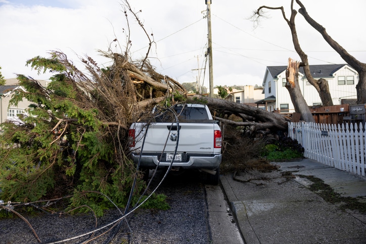
In the Coast Ranges and Sierra Nevada, particularly on west- and southwest-facing slopes, rainfall totals are forecast to range from 4 to 12 inches, with a Local StormMax of 20 inches. At times, multiple inches of rain may fall within hours, overwhelming drainage systems and causing small streams and short-run rivers to overflow. As soils become saturated, the risk of debris flows, hillside collapses, and road washouts will increase.
From Tuesday night through Christmas night, the second atmospheric river will deliver rain of varying intensity across Central and Southern California. The Los Angeles basin is forecast to receive 2 to 4 inches of rain. Downtown Los Angeles recorded 5.53 inches of rain in November, nearly seven times its historical average. While December has remained dry so far, the upcoming storm may produce one to two times the city’s average December rainfall of 2.48 inches.
On the southwest-facing hillsides of the Transverse Ranges, rainfall totals of 4 to 8 inches are expected. Even the Southeastern California desert areas may receive between 0.25 inches and 1 inch of rain. As in Northern California, urban flooding, mudslides, and washouts remain concerns.
Travel and Aviation Disruptions
As heavy rain and gusty winds affect major hubs including San Francisco, Los Angeles, and San Diego, airline delays and flight cancellations are expected. AccuWeather notes that these disruptions may ripple across the national airline industry as displaced aircraft and crews require rescheduling.
Wind and Coastal Impacts
The storm responsible for the atmospheric rivers may rapidly intensify offshore. AccuWeather meteorologists note that the system has the potential to become a bomb cyclone, though its impacts will be significant regardless of whether it meets formal criteria.
Strong winds are forecast along the Northern and Central California coast, with frequent gusts of 50 to 70 mph and higher gusts over mountain ridges and gaps. The AccuWeather StormMax for wind is 130 mph in elevated terrain. Along the coast, heavy wave action is expected, with overwash possible on Southern California beaches.
These winds may cause sporadic to regional power outages. Loose outdoor items, including holiday decorations, could become hazards. Crosswinds may also increase the risk of rollovers for high-profile vehicles.
Significant Snowfall in the Sierra Nevada
As colder air moves in, snow levels will drop across the Sierra Nevada and the Siskiyous. While Donner Pass along Interstate 80 may see rain mixed with a couple of inches of snow through Tuesday, heavier snowfall is expected from late Wednesday through Friday.
During that period, 1 to 2 feet of snow may accumulate at pass levels, potentially bringing travel to a standstill. Over the course of the week, AccuWeather projects that at least 10 feet of snow could fall across higher ridges and peaks in the Sierra Nevada.
While ski resorts benefit from natural snowfall during the holiday season, excessive accumulations may block access roads to resorts at higher elevations.
Conditions After Christmas
Late this week and into the weekend between Christmas and New Year’s, the overall moisture supply will diminish. However, enough residual moisture will remain to produce periodic showers statewide. With colder air in place, snow showers will continue in the Sierra Nevada and may also affect Southern California mountain passes, including portions of Interstate 5 and Interstate 15.
The same stormy pattern will continue to deliver rain and mountain snow to Oregon and Washington, where recent atmospheric rivers have already produced heavy precipitation. Ongoing moisture may worsen small-stream flooding at the local level. In addition, some Pacific moisture will extend inland, bringing valley rain and mountain snow to the Intermountain West into next weekend.
For the insurance industry, the evolving weather pattern underscores the potential for widespread travel disruptions, localized flooding, wind damage, and winter weather impacts during one of the busiest periods of the year.
Get the latest insurance market updates and discover exclusive program opportunities at ProgramBusiness.com.