


Weather will deteriorate along Florida’s southeast coast as Tropical Storm Nicole approaches the state and becomes a hurricane by the time it reaches land.
Palm Beach County ordered the evacuation of coastal communities and vulnerable areas in preparation for a possible direct hit, as schools closed and residents braced for a rare November hurricane.
Nicole’s winds remained at 70 mph Wednesday morning, with the storm expected to hit Florida’s east coast as a Category 1 hurricane Wednesday night or early Thursday, according to the National Hurricane Center’s 4 a.m. Wednesday update.
According to the National Weather Service, the slight shift in the forecast path to the south increased the chances of hurricane-force and tropical-force winds in Broward and Palm Beach counties.
The chance of sustained hurricane-force winds, defined as winds of at least 74 miles per hour, was estimated to be 10-15% for northeastern Palm Beach County, 5-10% for the rest of Palm Beach County, and less than 5% for the rest of South Florida. The likelihood of high-end tropical-force winds, defined as speeds of at least 58 mph, was 20-40% in Palm Beach County and 10-20% in Broward County, with the highest risk at each county’s northern end.
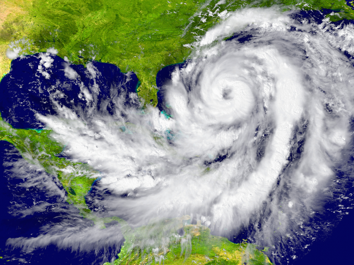
According to the hurricane center, the storm was 270 miles east of West Palm Beach at 4 a.m. Wednesday, moving west-southwest at 13 mph. Winds of tropical storm force extend up to 460 miles from Nicole’s center.
The storm is so large, according to Ana Torres-Vazquez, a meteorologist with the National Weather Service in Miami, that the precise point of landfall is less important, with all of South Florida at risk of high winds and storm surge.
“The main period of the event will be sometime late Wednesday into Thursday during the day,” she said. “However, things will gradually deteriorate.” Windy and breezy conditions have already been observed. [By Wednesday,] you’ll notice a gradual increase in wind speeds and a gradual increase in dangerous rain conditions.”
Palm Beach County Mayor Robert Weinroth announced the evacuation of zones A and B, which include barrier islands, low-lying areas, and mobile home communities, at a 2 p.m. news conference. Residents can find their evacuation zone by clicking here.
The evacuations, which go into effect at 7 a.m. Wednesday, affect approximately 52,000 mobile home residents throughout the county and 67,000 coastal residents, according to Palm Beach County Administrator Verdenia Baker.
“We saw what happened in Lee County,” Weinroth said, referring to Hurricane Ian’s storm surge, which drowned coastal residents. “There were people who stayed because they didn’t believe there was an emergency, and many of those people later regretted their decision.”
Some residents at Meadowbrooke Mobile Home Park in West Palm Beach were surprised to learn they were being ordered to evacuate. Some were planning to leave, while others were undecided.
“It’s scary,” said Ashley Flores, 15, whose family had not evacuated in her ten years there and was hesitant to leave. “But we’re just going to let it play out how it will.”
Jessica Mayouin, 21, said she and her three family members may decide to stay at a relative’s home in the county rather than their manufactured home.
“This is a very weak trailer,” she said of theirs.
Esmeralda Gomez, who lives in the mobile home park with her children and extended family, said she and her family will most likely seek shelter in a hotel during the storm.
“It feels safer for the kids,” she said.
Public schools in Broward and Miami-Dade counties, as well as Palm Beach County, will be closed on Wednesday and Thursday.
Several shelters will open at 7 a.m. Wednesday at seven schools: Independence Middle School, Palm Beach Gardens High School, Palm Beach Central High School, Park Vista High School, Lake Shore Middle School, Pahokee Middle-Senior High School, and Dr. Mary McLeod Bethune Elementary School. West Boynton Recreation Center has a pet-friendly shelter.
A hurricane warning was issued from Palm Beach County to Volusia County on Tuesday. A hurricane warning means that winds of 74 miles per hour or higher are expected within 36 hours.
“We expect Nicole to take advantage of this warm water and intensify to a hurricane as it approaches the coast,” Michael Brennan, acting deputy director of the National Hurricane Center, said in a Facebook broadcast.
According to the National Weather Service, the storm’s current path poses the greatest threat to northeastern Palm Beach County in South Florida.
“Damaging hurricane force winds expected in portions of coastal Palm Beach County (east of I-95) Wednesday night/early Thursday,” according to the weather service. “Damaging tropical storm force winds are expected over most of Palm Beach County and parts of Broward County, primarily near and along the coast.”
Nicole is expected to reach a top wind speed of 75 mph as it approaches Florida, making it a Category 1 hurricane.
Nicole will move across central and northern Florida and into southern Georgia on Thursday and Thursday night after approaching Florida on Wednesday night or early Thursday, according to the center’s latest advisory.
According to the National Weather Service, “life-threatening” storm surge is possible along the Broward and Palm Beach county coasts. Storm surge, the wind-driven rise in sea levels that killed many people when Hurricane Ian hit the Gulf coast in September, could reach 2 to 4 feet in South Florida and be accompanied by “large and destructive waves,” according to the National Hurricane Center.
The storm’s wind field is unusually large, as shown on the hurricane center’s map in dark yellow, which means that wherever Nicole’s center strikes, the entire east coast of Florida is likely to experience high winds, heavy rain, and storm surge.
“Do not concentrate on Nicole’s precise track because it is expected to be a large storm with hazards extending well to the north of the center, outside of the forecast cone,” the hurricane center said at 5 a.m. Tuesday.
Tropical storm conditions, defined as winds of at least 39 miles per hour, are expected to arrive in Florida early Wednesday, intensifying to hurricane status that night.
On Monday, Gov. Ron DeSantis declared a state of emergency in 34 Florida counties, including Broward, Miami-Dade, and Palm Beach.
Officials with the Florida Division of Emergency Management recommend storing a week’s worth of non-perishable packaged and canned foods and beverages, one gallon of water per person per day, non-electric can openers, paper and plastic utensils, pet food and supplies, gasoline, first-aid supplies, medications, cell phone chargers, batteries, flashlights, and cash, as well as important documents.
Impact on South Florida
Eric Silagy, president and CEO of Florida Power & Light Company, warned that the storm will knock down trees and vegetation that were weakened during Hurricane Ian.
“We are very likely to see outages as a result of the storm,” Silagy said.
A hurricane watch is in effect from Hallandale Beach to Boca Raton, Lake Okeechobee, and the Flagler/Volusia County line to Ponte Vedra Beach. A hurricane warning has been issued for several islands in the northwest Bahamas, as well as Boca Raton to the Flagler/Volusia County line.
A tropical storm warning has been issued for Hallandale Beach to Boca Raton, Lake Okeechobee, the Flagler/Volusia County line to Georgia’s Altamaha Sound, and several islands in the northwestern Bahamas. Tropical storm warnings are in effect from South Hallandale Beach to North Ocean Reef, from Bonita Beach to the Ochlockonee River, and from Altamaha Sound in Georgia to the South Santee River in South Carolina.
A storm surge warning has been issued for the entire panhandle, from the Ochlockonee River to Indian Pass. Storm surge warnings are in effect from south of North Palm Beach to Hallandale Beach, from the Anclote River to the Ochlockonee River, and from Georgia’s Altamaha Sound to South Carolina’s South Santee River. Storm surge warnings are in effect in Florida from North Palm Beach to Altamaha Sound, and from the mouth of the St. Johns River to Georgetown.
According to the weather service, South Florida will receive the most rain from the storm between Wednesday and Thursday. In parts of Palm Beach and Broward counties, 4 to 6 inches are expected, with higher amounts possible in some areas.
The latest hurricane center advisory stated that “the combination of a dangerous storm surge and the tide will cause normally dry areas near the coast to be flooded by rising waters moving inland from the shoreline.”
Storm surge could reach 2 to 4 feet from Hallandale Beach to North Palm Beach, and 1 to 2 feet from Ocean Reef to Hallandale Beach, including Biscayne Bay. Storm surge could reach 3 to 5 feet from North Palm Beach to Altamaha Sound, according to the center’s most recent advisory.
Tornadoes are possible in eastern Florida, Georgia, and South Carolina from late Wednesday night to Friday, according to the hurricane center.
Forecasters are also keeping an eye on a stormy area of low pressure in the central Atlantic Tuesday night, 950 miles west-southwest of the Azores Islands. Forecasters believe it will merge with a cold front on Wednesday and has a low chance of developing in the next five days.
So far this season, there have been two major hurricanes (Category 3 or higher): Fiona and Ian.
Owen will be the next named storm to form.
According to NOAA, at least four more hurricanes will form before the hurricane season officially ends on November 30.